Crossing the Red Sea or the Reed Sea
The Real crossing site/Traditional site
The information here presented was drawn from the work of Mr. Ron Wyatt (No blood-line of mine that I know of). When you look at the work of Mr. Wyatt you will find that biblical scholars will say that it is all phony because he is not a true archaeologist since he has had no training. Biblical Scholars? Didn't Paul state that 1Cor. 1:26 "For ye see your calling, brethren, how that not many wise men after the flesh, not many mighty, not many noble, are called: 1Co 1:27 But God hath chosen the foolish things of the world to confound the wise; and God hath chosen the weak things of the world to confound the things which are mighty;" and 1Cor 1:26 "For ye see your calling, brethren, how that not many wise men after the flesh, not many mighty, not many noble, are called:"
A controversy has boiled for centuries as to the meaning of Yam Sup (pronounced as yahm suph) which we translate as Red Sea. Yam certainly means sea, there is no doubt, but Sup does not mean red. If it remained true to the Hebrew language, it should have been yam Adam, where Adam is translated as red.
Sup traditionaly means reed, or rushes. Some so-called scholars in seminaries say that it was not the Red sea but the Reed sea which is shallow enough to walk thru. One student responded to that accusation by saying, "that is a greater miracle. To think that God could drown all those Egyptians in ankle deep water".Exo. 15:5 "The depths have covered them: they sank into the bottom as a stone."
Looking at a map we see that the Red Sea is made up of a long body of water with two fingers extending north west and north east. These are the Gulf of Suez and the Gulf of Aqaba. The children of Israel lived in the Nile delta area or the land of Rameses called Goshen. They first encamped at the northern end of the Gulf of Suez or Succoth at the beginning of the Exodus. This was the first point where they went into the camping mode."And the children of Israel journeyed from Rameses to Succoth, about six hundred thousand on foot that were men, beside children." Exodus 12:37. Actually 6o3,550, this number came from the numbering of the tribes in Numbers 1:46 and did not take in to account women, children under 20 years of age, and the entire tribe of Levi. This amounted to about 2-3 million people plus livestock and belongings. Succoth had to be a place large enough for this tremendous amount of people and flocks to assemble. A place called variably "Tharu", T'aru" and "Takut," fits the description of Succoth perfectly. Where one would leave Egypt proper and go into the Sinai desert, there was a fortress and a bridge. Inscriptions tell us that this fortress was called Tharu (or one of the various spellings). It is located near the Delta, or "Rameses," where the Israelites were living, and was where the Egyptian army assembled in preparation for their military expeditions to the north.
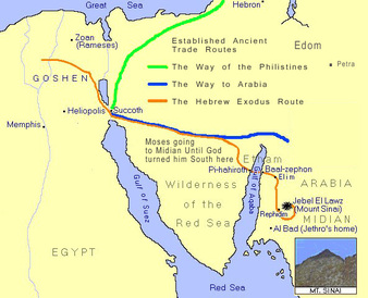
The shortest route to the Promised Land was through the land of the Philistines, but God didn't want them to take this route, He wanted them to take the Southern route through the mountainous wilderness of the sinai Peninsula. Exo 13:17-18 "And it came to pass, when Pharaoh had let the people go, that God led them not through the way of the land of the Philistines, although that was near; for God said, Lest peradventure the people repent when they see war, and they return to Egypt: But God led the people about, through the way of the wilderness of the Red sea: and the children of Israel went up harnessed out of the land of Egypt."
Since God told Moses not to take the shortest route through the Philistine country Exo. 13:17 he headed for the area he knew for the last forty years, Midian. Exo. 13:20 "And they took their journey from Succoth, and encamped in Etham, in the edge of the wilderness." Etham is not believed to be a singular location. It was a designation of the land that lay around the mid-northern edge of the Gulf of Aqaba. We know this because once they cross the sea, they are still in an area called Etham. Exo. 13:18 "But God led the people about, through the way of the wilderness of the Red sea..." The wilderness of the Red sea was the mountainous land between the Gulf of Suez and the Gulf of Aqaba, which are two arms of the Red sea and thereby were called the Red sea. It was the northern tip of the Gulf of Aqaba that Solomon built his fleet of ships (1Ki. 9:26. calls this the Red Sea. "And king Solomon made a navy of ships in Eziongeber, which is beside Eloth, on the shore of the Red sea, in the land of Edom.")
Exodus Route through the wilderness of the Red Sea
Num. 33:8 "And they departed from before Pihahiroth, and passed through the midst of the sea into the wilderness, and went three days' journey in the wilderness of Etham, and pitched in Marah." It was while they were at Etham on the western side of the sea that God told Moses: Exo. 14:2-3"Speak unto the children of Israel, that they turn and encamp before Pihahiroth, between Migdol and the sea, over against Baalzephon: before it shall ye encamp by the sea. For Pharaoh will say of the children of Israel, They are entangled in the land, the wilderness hath shut them in."
In order for them to be "entangled in the land," they would have to be traveling through an area of Wadis (canyons) with high mountains all around, which would seem to hem them in. (See picture below) This takes place prior to crossing the sea. Knowing this, there had to be an area which would terminate on a beach or shore of the sea; and which was large enough to hold perhaps 2 or 3 million people, as well as their flocks. There is a beach of tremendous size on the Gulf of Aqaba at Nuweiba, and the only passage to it is through an 18 mile long wadi system called the Wadi Watir.
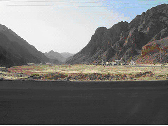
Notice the steep sides of the Wadi.
The Wadi Watir ending at Newiba beach
The Israelites were prevented from traveling north by the presence of an Egyptian military fortress. Indeed to the north of the mouth of Wadi Watir we find an ancient fortress, could this have been the place referred to in the Bible as, Migdol, (Exo. 14:2). From "Etham in the edge of the wilderness", they changed their direction of travel from a northerly direction, (which would have soon taken them around the northern tip of the sea,[the Gulf of Aqaba]) and went south (see map above), through a wadi system that must have appeared like an endless maze to them. Additionally there were mountains obstructing their escape. To the south the mountains came down to the sea, as mentioned by Josephus, "For there was [on each side] a [ridge of] mountains that terminated at the sea, which were impassable by reason of their roughness, and obstructed their flight" Antiquities of the Jews, Bk. 2, 15-3. Hemmed in to the left and right, they could only travel in only one direction - and the only path through that wadi leads to a tremendous beach. You can see the mountains at the beach today. The people were about to turn against Moses because he had led them to an area where they were trapped and would surely die, or so they thought.
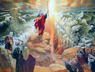
Of course they could not turn around and retrace their steps as the Egyptian army was pursuing them. God had brought them to a point where only He could deliver them, "And Moses said unto the people, fear not, stand still, and see the salvation of the LORD, which He will show you today, for the Egyptians whom you have seen today, you shall see them no more again forever.... and the LORD caused the sea to go back by strong east wind all that night, and made the sea dry land, and the waters were divided. And the children of Israel went into the midst of the sea upon the dry ground: and the waters were a wall unto them on their right hand, and on their left." (Exo. 14:13 Exo. 14:21-22).
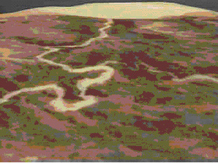
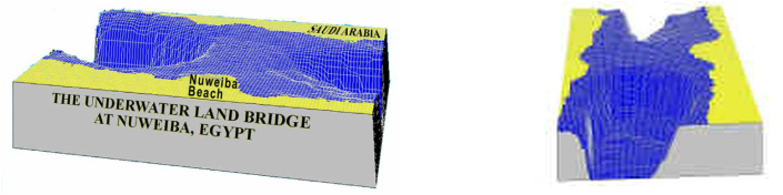
Along the length of the the Gulf of Aqaba, depths reach to an average of 5000 feet and the Egyptian shoreline drops steeply under water at a slope of about 45 degrees. If the Israelites had tried to have crossed anywhere else along the Gulf of Aquaba they would have been faced with an extremely steep drop to about 5000 feet (The Gulf's deepest point is 6070 ft.). With all of their animals and wagons, the task would have been practically impossible. Perhaps most amazing of all, is the presence of an under water land bridge. Only here, on the shores of Nuweiba, does the 'pathway' drop off at a gradual slope of 6 degrees, to a depth of only 100 meters (328 feet). The crossing path is about a quarter to a half mile wide and is on a gradual slope down to the bottom of the Red Sea and then up to the Saudi beach. The Bible describes it as, "Away in the sea and a path in the mighty waters" (Isa. 43:16-17) The distance from Nuweiba to Saudi Arabia is about eight miles. To me, it is so like God to know, that during the receeding of the Noatic flood sand from above would filter down to Nuweiba beach and into the Gulf of Aqaba creating a "land bridge". Look at the diagram below to see the topigraphical rendition.
Moving on toward Mt. Sinai
The traditional site for Mt. Sinai was the southern Sinai Pennsula. The Sinai peninsula has traditionally been considered Sinai's location by Christians, although it should also be noted that the peninsula gained its name from this tradition, and was not called that in Josephus' time or earlier. The Sinai was earlier inhabited by the Monitu and was called Mafkat or Country of Turquoise. In early Christian times, a number of Anchorites settled on Mount Serball, considering it to be the biblical mountain. The Catholics latched on to the mountain and built St. Catherine's Monastery at it's base. And so the tradition continued until recently. We know that Mt. Siani was in Arabia Gal.4:25 " For this Hagar is mount Sinai in Arabia" and was in the same area as Jethro's home in Midian according to Exo. 3:1 "Now Moses kept the flock of Jethro his father-in-law, the priest of Midian: and he led the flock to the backside of the desert, and came to the mountain of God, even to Horeb." God had led the children of Israel here because He told Moses to bring them back here to worship me in Exo. 3:12 "And he said, Certainly I will be with thee; and this shall be a token unto thee, that I have sent thee: When thou hast brought forth the people out of Egypt, ye shall serve God upon this mountain." We also know that Mt. Sinai is in Arabia and not the Sinai peninsula in Gal 4:25 "For this Hagar is mount Sinai in Arabia, and answereth to Jerusalem which now is, and is in bondage with her children."
Icing on the cake
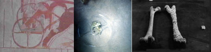
Off Nuwieba beach diving down to the sea bed, in 1978, Ron Wyatt (A self-taught Archeologist and no relation) and his two sons found and photographed numerous coral encrusted chariot parts, numerous chariot wheels, plus human and horse bones at the crossing site. Several dives since then have revealed more and more evidence. One of his finds included an eight spoke chariot wheel, which Ron took to the director of Egyptian Antiquities, Dr. Nassif Mohammed Hassan. After examining it he immediately announced it to be of the eighteenth dynasty, dating the exodus to 1446 BC. When asked how he knew this Dr. Hassan explained that the eight spoke wheel was only used during this period, the time of Ramases II and Tutmoses (Moses). Chariot boxes, horse and human skeletal remains, four, six and eight spoke chariot wheels all lie as a silent testimony to the miracle of the parting of the Red Sea.
The traditional site for Mt. Sinai was the southern Sinai Pennsula. The Sinai peninsula has traditionally been considered Sinai's location by Christians, although it should also be noted that the peninsula gained its name from this tradition, and was not called that in Josephus' time or earlier. The Sinai was earlier inhabited by the Monitu and was called Mafkat or Country of Turquoise. In early Christian times, a number of Anchorites settled on Mount Serball, considering it to be the biblical mountain. The Catholics latched on to the mountain and built St. Catherine's Monastery at it's base. And so the tradition continued until recently. We know that Mt. Siani was in Arabia Gal.4:25 " For this Hagar is mount Sinai in Arabia" and was in the same area as Jethro's home in Midian according to Exo. 3:1 "Now Moses kept the flock of Jethro his father-in-law, the priest of Midian: and he led the flock to the backside of the desert, and came to the mountain of God, even to Horeb." God had led the children of Israel here because He told Moses to bring them back here to worship me in Exo. 3:12 "And he said, Certainly I will be with thee; and this shall be a token unto thee, that I have sent thee: When thou hast brought forth the people out of Egypt, ye shall serve God upon this mountain." We also know that Mt. Sinai is in Arabia and not the Sinai peninsula in Gal 4:25 "For this Hagar is mount Sinai in Arabia, and answereth to Jerusalem which now is, and is in bondage with her children."
Icing on the cake
Off Nuwieba beach diving down to the sea bed, in 1978, Ron Wyatt (A self-taught Archeologist and no relation) and his two sons found and photographed numerous coral encrusted chariot parts, numerous chariot wheels, plus human and horse bones at the crossing site. Several dives since then have revealed more and more evidence. One of his finds included an eight spoke chariot wheel, which Ron took to the director of Egyptian Antiquities, Dr. Nassif Mohammed Hassan. After examining it he immediately announced it to be of the eighteenth dynasty, dating the exodus to 1446 BC. When asked how he knew this Dr. Hassan explained that the eight spoke wheel was only used during this period, the time of Ramases II and Tutmoses (Moses). Chariot boxes, horse and human skeletal remains, four, six and eight spoke chariot wheels all lie as a silent testimony to the miracle of the parting of the Red Sea.
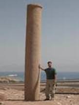
On the Nuwieba beach Ron found a column lying face down on the shore. On the Saudi side he found another exactly the same with an inscription in Archaic Hebrew that read, "MIZRAIM (Egypt), SOLOMON, EDOM, DEATH, PHARAOH, MOSES, YAHWEH." He believed that they were erected by Solomon to commemorate the crossing of the Red Sea. The inscriptions on the column found lying on the shore were eroded away. The authorities have since set it in concrete. King Solomon had these columns erected 400 years after the miracle of the crossing of the Red Sea on dry land. Solomon's sea port was at the northern tip of the Gulf of Aqaba at Eilat (1Ki. 9:26) and he was very familiar with the Red Sea crossing site, as it was in his neighborhood. The Bible even mentions this column! Isa. _19:19, "In that day there will be an altar to the Lord in the midst of the land of Egypt, and a pillar to the Lord at its border." The pillars are standing today.
